
[{
    "name": "Newsletter Promo",
    "id": "NewsletterPromo",
    "class": "inlineCenter",
    "insertPoint": "4",
    "component": "15264767",
    "requiredCountToDisplay": "0"
    },{
    "name": "Ad - Medium Rectangle CC01 - 300x250",
    "id": "AdMediumRectangleCC01300x250",
    "class": "inlineCenter",
    "insertPoint": "8",
    "component": "2963441",
    "requiredCountToDisplay": "12"
    },{
    "name": "Ad - Medium Rectangle LC01 - 300x250",
    "id": "AdMediumRectangleCC01300x250",
    "class": "inlineCenter",
    "insertPoint": "18",
    "component": "2963441",
    "requiredCountToDisplay": "22"
    },{
    "name": "Ad - Medium Rectangle LC09 - 300x250",
    "id": "AdMediumRectangleLC09300x250",
    "class": "inlineCenter",
    "insertPoint": "28",
    "component": "3252660",
    "requiredCountToDisplay": "32"
    }]

Highway 1's expanse of pavement threads above cliffs, bluffs, and beaches between Cambria and Carmel, carving a breathtaking path that undulates between awe and fear—depending on the driver.
Steep drop-offs and hairpin turns. Wild blue and teal water pockmarked by white surf and gray boulders. The Coastal Range in browns, beiges, and greens.
But the road isn't always open for drivers who want to meander its path.
In fact, it's closed right now, a result of the historic rains that pounded California more than a year ago. Thanks to landslides that are a familiar occurrence along the iconic road, Caltrans continues to battle the elements to reopen Highway 1 for the 4.5 to 7 million tourists who attempt to travel the route every year, the businesses that rely on them, and the 2,000 or so residents who depend on it for access to both their homes and the world beyond Big Sur.
"In the same way that we maintain access to our national parks, we're committed to maintaining access to the Big Sur Coast. It's a unique resource," Caltrans District 5 Public Information Officer Kevin Drabinksi said. "It requires a lot, you know."

California has spent more than $325 million on emergency repair contracts along the Big Sur stretch of Highway 1 since the 2016-17 fiscal year. According to Caltrans data, more than a third of that ($129 million) was spent last year, mostly thanks to the slew of storms in January. From Dec. 1, 2022, to Jan. 16, 2023, the Bay Area News Group reported, Mining Ridge in Big Sur recorded almost 85 inches of rain.
Caltrans preemptively closed the highway to vehicles each time an atmospheric river threatened the forecast, and by Jan. 5, 2023, the transportation agency reported its first slide along the Big Sur coast: Polar Star south of Ragged Point, effectively closing the highway until repairs could be made.
By the end of January, there were several more slides between Ragged Point on the south end of Highway 1 and Lime Creek farther north, with the largest amount of activity at Paul's Slide just north of Limekiln State Park. More than a year later, Caltrans is still working to repair the site, with expected costs topping $60 million.
"We got hit pretty good," Drabinski said.
Caltrans was able to repair most of the damage along the highway, opening it up as far north and south as was safe. But the Paul's Slide area is a work in progress. It's a tricky area, he said, because that stretch of the Coastal Range is constantly shifting.
"We have photos and data going back to the 1970s about that slide and it's been active historically. It's a geologically active range of mountains. We refer to it as the Paul's Slide Complex," Drabinski said. "A series of slide areas ... across about 1,000 feet of mountain."

The last time Caltrans did a major repair in the area was 2017, when a January slide took out part of a lane. The agency put in a giant catchment basin as part of that repair, one that could mitigate slide activity and be excavated from time to time. The 2023 slide fell from 80 to 90 feet above that basin, filled it, and pushed onto and over the roadway, Drabinski said.
"The fact that the area is geologically active has an impact on our ability to maintain the roadway," Drabinski said. "At Paul's Slide, the volume and rate of movement of some 500,000 cubic yards of material caused the road to close. Slide activity is understood to be active throughout the area."
Over the course of 2023, the area continued moving, pushing a potential timeline for repair further and further out.
Repairing slide damage takes more than simply fixing the road where a slide occurred, he said, because it's not just the earth above it that moved. The land beneath the road also moved, and earth on either side of the slide is also unstable.
"Even if you lose a small section of road, it can take out up to 40 feet of roadway and take a long time for repair," he said.
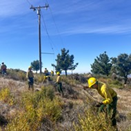
Caltrans workers have to excavate all the slide material, reintroduce fill that's stable enough to hold a road, bring the fill back up to the highway level, secure it with retaining material, and then lay the road on top. It's a process that many Caltrans employees who work in the Big Sur area are used to.

"A lot of the men and women out there making those repairs have years of experience and are seasoned at doing the work they do up and down the Big Sur coast," he said. "It's also good to know that you've got your best team out there making repairs."
At the Paul's Slide Complex, the repair job is even trickier.
"You have to be able to dance with the mountain, and if you know it's active, you kind of reduce the number of people working on it," he said. "It looks like ballet, the vehicles driving on it."
With the help of a landslide hazard plan developed in collaboration with the California Geological Survey, Caltrans engineers, geologists, and planners decided to move the highway inland at Paul's Slide, recontouring the mountain in a way that takes away the potential for slide activity and takes advantage of its natural features, Drabinski said. The agency also created an even larger catchment area to mitigate future movement.
"It was a repair design that was developed in response to the mountain continuing to slide," Drabinski said. "This is a good way for us to be able to defend the road."
Highway 1 is open for travel from the Cambria/San Simeon area north to Limekiln State Park and from the Monterey/Carmel area to 0.6 miles south of Lucia. Caltrans estimates it can have those lanes open to through traffic in late spring.

Latest in Get Outside


More by Camillia Lanham
