[{
    "name": "Newsletter Promo",
    "id": "NewsletterPromo",
    "class": "inlineCenter",
    "insertPoint": "4",
    "component": "15264767",
    "requiredCountToDisplay": "0"
    },{
    "name": "Ad - Medium Rectangle CC01 - 300x250",
    "id": "AdMediumRectangleCC01300x250",
    "class": "inlineCenter",
    "insertPoint": "8",
    "component": "2963441",
    "requiredCountToDisplay": "12"
    },{
    "name": "Ad - Medium Rectangle LC01 - 300x250",
    "id": "AdMediumRectangleCC01300x250",
    "class": "inlineCenter",
    "insertPoint": "18",
    "component": "2963441",
    "requiredCountToDisplay": "22"
    },{
    "name": "Ad - Medium Rectangle LC09 - 300x250",
    "id": "AdMediumRectangleLC09300x250",
    "class": "inlineCenter",
    "insertPoint": "28",
    "component": "3252660",
    "requiredCountToDisplay": "32"
    }]
"Mind the gap."
That's what one Los Osos resident advised representatives of the National Oceanic and Atmospheric Administration (NOAA) on Sept. 25 as community members gathered to give input on the marine sanctuary designation process.
Public comment for the proposed Chumash Heritage National Marine Sanctuary is underway until Oct. 25. NOAA is welcoming observations on its draft documents—a comprehensive list containing a preliminary management plan, environmental impact statement, and proposed regulations and boundaries.
NOAA released these much-awaited documents close to two years after it started the designation process in November 2021 and eight years after the Northern Chumash Tribal Council submitted the sanctuary nomination application. The federal agency targets ultimate sanctuary designation for 2024.
But many were disappointed in NOAA's proposed boundaries for the sanctuary. At the first public comment session on Sept. 25, speakers urged NOAA to revert to its initial boundary selection.
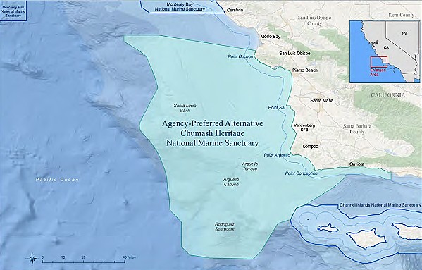
Covering 7,600 square miles across the SLO and Santa Barbara counties coast, the original boundary proposal connected with the Monterey Bay National Marine Sanctuary to create a contiguous protected space. The proposed boundary started from the waters off Cambria and Morro Bay and snaked south to the Gaviota Coast touching the Channel Islands National Marine Sanctuary.
NOAA now prefers a different boundary—one that's 2,000 square miles smaller, leaving a gap between the Monterey Bay sanctuary and the proposed Chumash Heritage sanctuary. It would start from Point Buchon and wind down farther south than the initial boundary to cover more of the Gaviota Coast, but it cut out the waters off Cambria and Morro Bay, the Morro Bay Estuary, and Morro Rock, much to the dismay of many community members, environmentalists, the Northern Chumash Tribal Council, and state Sen. John Laird (D-Santa Cruz).
Kara Woodruff, Laird's district director, read his letter during the public comment period.
"This excluded region is a biodiversity hotspot and would be a significant obstacle to the long-term protection of Central Coast marine life, including whales, sea turtles, sea lions, seals, sea otters, dolphins, sharks, and fish," Laird wrote in his letter. "It appears, however, that the 'agency preferred alternative' throws the 'baby out with the (ocean) water.'"
NOAA's preference for the new boundary is two-fold. First, the draft environmental impact statement claims that it left out waters off Cambria and Morro Bay because of the possible installation and management of roughly 30 subsea electrical transmission cables for an offshore wind energy development.
Under the leadership of the Bureau of Ocean Energy Management, the wind energy area is situated in waters off Morro Bay outside the proposed boundary, but the subsea cables could be placed within the section of Morro Bay waters that NOAA's preferred boundary excludes. Offshore wind energy cabling has never run through sanctuary waters, before and NOAA's concerned about that setting a dangerous precedent of seabed disturbance if it extends the boundary as originally envisioned.
"In excluding this area, NOAA anticipates developers will be able to plan infrastructure for this area, which may minimize the potential requests to use other parts of the proposed sanctuary," the draft proposed rule read.
But worries persist that the 2,000-square-mile separation will harm the 20 species of birds, white sharks, bluefin tuna, sea lions, leatherback turtles, whales, sea otters, elephant seals, among other wildlife that rely on migration for survival.
Secondly, NOAA prefers to leave out the Cambria and Morro Bay waters because of naming disputes. Salinan tribes identified parts of that area as their ancestral homeland and objected to the proposed sanctuary being named "Chumash." The Xolon Salinan tribe supported the sanctuary designation but only if its name is changed. The Northern Chumash Tribal Council, however, stressed the sanctuary name "Chumash" to honor the late Chief Fred Collins' leadership in sanctuary nomination. The tribal council also wants the largest possible boundaries for the proposed sanctuary, meaning it should start from the waters off Cambria and cover the new extension of Gaviota Coast.
Dissatisfied with NOAA's reasoning, Morro Bay resident Betty Winholtz said people "feel stabbed in the back."
The final commenter, another Morro Bay resident, said she agreed with Winholtz. She then likened NOAA's changes in boundary selection to the "the way our [SLO County] supervisors cut and sliced our county for an election and suddenly they changed it back."
"It serves somebody's purpose but not the general public's," she said.
The next public comment session will take place on Sept. 27 at 5 p.m. at the Dick DeWees Community Center in Lompoc. An online session is set for Oct. 12 at 1 p.m. Δ
Submit public comment online at www.regulations.gov/commenton/NOAA-NOS-2021-0080-1228.
Latest in News
Comments (3)
Showing 1-3 of 3
Readers also liked…
-

Coast Unified teachers upset over new position's salary and qualifications
Oct 20, 2022 -

SLO police identify alleged driver who hit and killed couple
Dec 22, 2022 -

When the levee breaks: Oceano residents, county officials walk a tightrope of regulations to manage Arroyo Grande Creek, which some say led to the levee's failure in January
May 18, 2023


