
Morro Rock, Montaña de Oro, Irish Hills among areas reviewed by feds for fracking and oil drilling
By Peter Johnson[{
"name": "Ad - Medium Rectangle CC01 - 300x250",
"id": "AdMediumRectangleCC01300x250",
"class": "inlineCenter",
"insertPoint": "8",
"component": "2963441",
"requiredCountToDisplay": "12"
},{
"name": "Ad - Medium Rectangle LC01 - 300x250",
"id": "AdMediumRectangleCC01300x250",
"class": "inlineCenter",
"insertPoint": "18",
"component": "2963441",
"requiredCountToDisplay": "22"
},{
"name": "Ad - Medium Rectangle LC09 - 300x250",
"id": "AdMediumRectangleLC09300x250",
"class": "inlineCenter",
"insertPoint": "28",
"component": "3252660",
"requiredCountToDisplay": "32"
}]
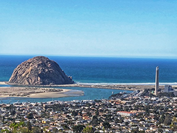
State parks, historic landmarks, and open spaces throughout San Luis Obispo County are currently under review as potential fracking and oil drilling sites by the Trump administration.
More than 123,000 acres of land in SLO County are subject to federal Bureau of Land Management (BLM) control. As a result they have been included in a far-reaching BLM environmental study of property in Central California that can be leased for fracking or oil drilling.
The areas under review include Morro Rock, Montaña de Oro State Park, Irish Hills Natural Reserve, and several other high-profile locations. That's according to environmental nonprofit Los Padres ForestWatch, which used GIS mapping to pinpoint what areas the BLM is reviewing.
"We're talking about nature reserves, areas along the Carrizo Plain, Los Padres National Forest, across the street from schools. ... These places are completely inappropriate for drilling," ForestWatch Executive Director Jeff Kuyper said. "We should be starting from which areas, if any, is it safe to frack [or] drill for oil?"
Kuyper requested the raw mapping data from the BLM after the agency initially provided the public with a "low-resolution" map that obscured the specific lands under review. In 2016, ForestWatch was part of a group of environmental groups that successfully sued the BLM to require it to examine the environmental impacts of expanding fracking on California's public lands.
"We requested the [data] to get a more full assessment of what parcels were going to be subject to drilling and fracking," Kuyper said. "We were able to plug it into our program and really zoom in and take a look at what parcels were vulnerable."
SLO County lands included in the BLM's study, from highest acreage to lowest, are: Camp Roberts (43,000 acres); Lake Nacimiento and Santa Lucia Range (32,000 acres); land surrounding the Carrizo Plain National Monument (28,140 acres); La Panza Mountain Range (7,000 acres); Santa Margarita Lake, Park Hill, and Calf Canyon areas (5,000 acres); Huasna Valley (2,500 acres); Montaña de Oro (1,222 acres); Whale Rock Reservoir (980 acres); private land neighboring Machesna Mountain Wilderness (480 acres); Lopez Lake (324 acres); Reservoir Canyon Nature Reserve (200 acres) and Irish Hills (76 adjacent acres) near SLO; land directly across from Los Osos Middle School (5 acres); and Morro Rock ("atop and surrounding" the volcanic plug).
In addition, nearly 122,000 acres of Santa Barbara County and 28,000 acres of Ventura County are included in the study, according to ForestWatch. In total, about 1.6 million acres are under review across several counties.
Kuyper said the scope of the BLM's review indicates that it's making a "default assumption that any land or mineral rights they own should be open to drilling ... until the public can prove otherwise."
Gabe Garcia, BLM's field manager in Bakersfield, told New Times that the lands have been open to oil and gas leases for decades as part of its resource management plan. But the BLM has not issued a new lease in California in at least five years.
"It's nothing that's new," Garcia said. "Some lands may have higher potential than others. ... Our focus is how does hydraulic fracturing impact those lands?"
Local residents can weigh in on the BLM's environmental review until Sept. 7, when the public comment period closes.
"Now's our opportunity early in the process to point these issues out," Kuyper said.
The feds' look at unleased lands for oil or gas extraction hits as SLO County residents prepare to vote in November on Measure G, which would place a moratorium on oil and gas drilling in the county. If passed, Measure G would not apply to federally managed lands. Δ

Latest in News
-
Controversy erupts in Arroyo Grande, again, over City Hall Pride flag
Apr 25, 2024 -
Two residents sued Atascadero for flood damage, increasing the list of storm-related lawsuits in SLO County
Apr 25, 2024 -

Student journalist sues Cal Poly for California Public Records Act violation
Apr 25, 2024 - More »
Comments (15)
Showing 1-15 of 15
Readers also liked…
-

Coast Unified teachers upset over new position's salary and qualifications
Oct 20, 2022 -

SLO police identify alleged driver who hit and killed couple
Dec 22, 2022 -
When the levee breaks: Oceano residents, county officials walk a tightrope of regulations to manage Arroyo Grande Creek, which some say led to the levee's failure in January
May 18, 2023

More by Peter Johnson
-
As local beavers rebuild their dams after a brutal winter, the SLO Beaver Brigade seeks to rebuild their population on the Central Coast
Jun 30, 2023 -

San Luis Obispo emergency responders urge caution on city trails but are trained and equipped to rescue if crisis strikes
Jun 30, 2023 -

Morro Bay’s inaugural Ironman 70.3 drew thousands of triathletes and spectators
Jun 30, 2023 - More »
