

[{
    "name": "Ad - Medium Rectangle CC01 - 300x250",
    "id": "AdMediumRectangleCC01300x250",
    "class": "inlineCenter",
    "insertPoint": "8",
    "component": "2963441",
    "requiredCountToDisplay": "12"
    },{
    "name": "Ad - Medium Rectangle LC01 - 300x250",
    "id": "AdMediumRectangleCC01300x250",
    "class": "inlineCenter",
    "insertPoint": "18",
    "component": "2963441",
    "requiredCountToDisplay": "22"
    },{
    "name": "Ad - Medium Rectangle LC09 - 300x250",
    "id": "AdMediumRectangleLC09300x250",
    "class": "inlineCenter",
    "insertPoint": "28",
    "component": "3252660",
    "requiredCountToDisplay": "32"
    }]
But there are some trails that will make you regret your decision to tackle them. Those trails take work. Your legs will scream and your lungs might too—on the way up and on the way down. But the payoff is big, with views that will take your breath away and a gigantic sense of accomplishment when you finally get back to the car.
If you’re looking for a day of adventure that mixes pleasure with pain, these hikes are for you.
Gaviota PeakIf it’s hot, skip this trail. The 6.5-mile loop climbing 2,150 feet that takes you to Gaviota Peak isn’t known for shade. It’s punishing in the wrong conditions and tough when the conditions are perfect—a classic Central Coast morning with heavy fog that clears right before you hit the summit. Just off Highway 101 in Gaviota State Park, take the California Highway 1 exit, and find the frontage road. The trailhead is a twofer: Gaviota Hot Springs is close (if you can find it). The steady climb to the peak begins immediately, with a junction to the Trespass Trail a short distance from the parking lot. Take a right to enjoy views of the Gaviota coast south to Refugio and beyond as you hike to the 2,458-foot summit. The vistas are breathtaking, as is the hike itself. Take the Gaviota Peak Fire Road on the way back down for a well-rounded trip.
Buckeye Trail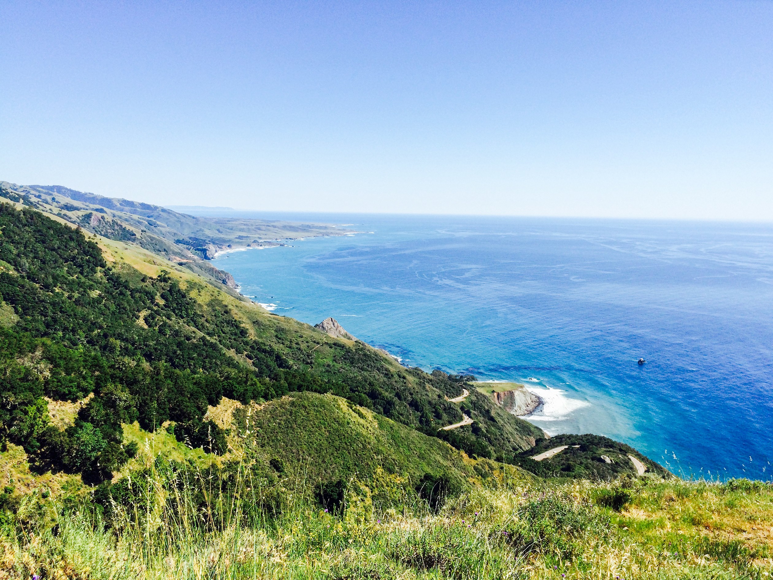
This is one of my favorite trails in Big Sur. It starts from the same bend in the road as Salmon Creek, roughly 27 miles north of Cambria. There’s parking along the shoulder and in a small lot adjacent to the long-closed Salmon Creek ranger station, where the Buckeye Trail begins. It’s a push from the very start, gaining about 575 feet of elevation in the first half mile with a reveal of the coast and Highway 1 that will help you catch your breath. The trail continues its climb across ravines, through cypress forests and chaparral, across streams, and along grassy meadows with insane views of the Big Sur coast, as your feet carry you ever higher. A solid day hike is the 6.5-mile out-and-back trip that turns around at Buckeye Camp, which sports picnic tables, campsites, a spring, and will put more than 1,500 feet of elevation gain on your altimeter.
Cerro Alto
With an elevation gain of 1,600 feet, there are two ways to hit one of the tallest vistas in SLO County: You can head straight up, or meander. The meander is still a burner that clocks in at 5.3 miles if you loop back down the steep trail. Download a hiking app to help you navigate this one as there are many spots where the trail forks or meets up with other trails. Find the trailhead at Cerro Alto Campground off Route 41 between Atascadero and Morro Bay. Don’t want to pay a fee to park? Tack another mile onto your trip one-way and park closer to the highway. The official Cerro Alto Trail starts from between campsites and the first segment is a casual, cool traipse beneath oak trees along the creek, eventually rising up the side of the mountain, leveling off, and then climbing again. A trail sign for the summit signals that your tree-covered journey is close to over, as the hike hits another, steeper gear through the chapparal. But that view! The entire string of Sisters, Morro Bay, and the Santa Lucia mountains are visible when you finally hit the 2,624-foot summit.

Latest in Get Outside


More by Camillia Lanham


