Future loss: Two decades of planning is put on hold as Atascadero residents worry about the impacts more than 500 proposed homes would bring
By Erica Hudson[{
"name": "Ad - Medium Rectangle CC01 - 300x250",
"id": "AdMediumRectangleCC01300x250",
"class": "inlineCenter",
"insertPoint": "8",
"component": "2963441",
"requiredCountToDisplay": "12"
},{
"name": "Ad - Medium Rectangle LC01 - 300x250",
"id": "AdMediumRectangleCC01300x250",
"class": "inlineCenter",
"insertPoint": "18",
"component": "2963441",
"requiredCountToDisplay": "22"
},{
"name": "Ad - Medium Rectangle LC09 - 300x250",
"id": "AdMediumRectangleLC09300x250",
"class": "inlineCenter",
"insertPoint": "28",
"component": "3252660",
"requiredCountToDisplay": "32"
}]
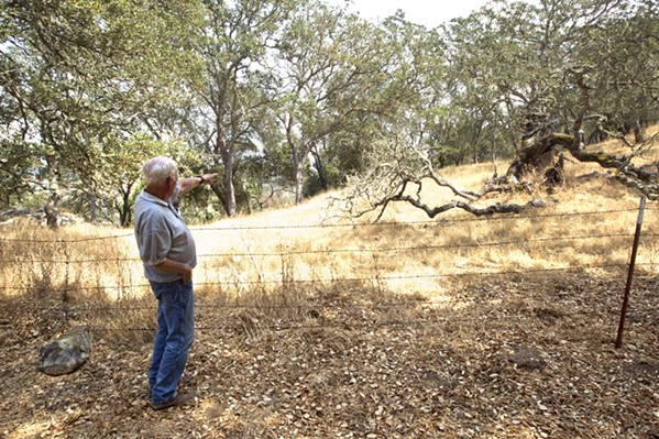
Sunlight glimmered off the large glass windows of the Lindal cedar home Red Heesch built in 1986. His greyish-blue eyes panned the horizon from his balcony, counting at least 36 different white, red, blue, black, and coastal live oaks that sink their roots deep into the golden ground of his front yard, where San Diego and San Dimas Road meet on a southwestern edge of Atascadero.
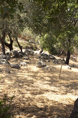
Streams gush through creek swales on each end of his yard during the winter, washing leaves and grass down to Atascadero Lake through two pipes. Heesch said that it takes a couple of months for the streams to get started, but then, they run dry in the summer. On that hot day in August, crumbled rocks and boulders are all that remain of a wet winter.
With one hand in the pocket of his jeans, he walks the perimeter of an agility course made for his two corgis, Lizzie and Tutti, to the dark metal fence that borders his property. Deer, wild turkeys, bobcats, coyotes, mountain lions, black bears, and cows occasionally wander along that barrier created to protect his companions from becoming a snack. Beyond that, thin wooden stakes are sprinkled like a breadcrumb trail, mapping out a potential road to the proposed commercial-residential development called Eagle Ranch.
If it moves forward, those 36 oaks will be clear-cut from his yard to make way for a road near an easement on his property. The life he's known for the last two decades would change.
Heesch moved from Houston, Texas, to the Central Coast to teach graphic communications at Cal Poly. He moved to the top of his hill for solitude 21 years ago and stayed to spend his days with family. Eagle Ranch's plans would crack into that peaceful existence, with more than 500 residential units, a hotel, a village center, and hiking trails proposed for the 3,000-plus acres behind the homes in his neighborhood.
"What it does is hit every single neighborhood in the vicinity with some kind of intrusion, and what it does for the neighbors, their families, and everything else ... it makes a freeway out of San Rafael [Road]," Heesch said.
The space beyond his driveway is identified as a future road, running from the west side of the ranch to Highway 101. San Diego Road, which currently hits a dead end in front of his house, is planned to be extended through to the other side of the development. San Rafael Road, a few neighborhoods east, could become a shortcut for Eagle Ranch residents to access highways 101 and 41.
Heesch and his neighbors with homes bordering the ranch expressed concerns about the traffic congestion from potentially thousands of new residents driving down windy, sharp roads like San Diego.
"How can any road be constructed there because of the terrain, and what is this going to do to my front yard?" said Heesh, who's had those questions since 2006, when he first found out about the project.
But until further notice, neighbors have nothing to worry about. This June, developers put the project on hold, giving city staff a rain check on the nearly 20-year conversation around annexing the county property to the city. The Eagle Ranch team asked Atascadero City Council to place the annexation proposal on pause while they figure out the fiscal impacts of the project. The city says in order for the development to move forward, the residential portion can't cost Atascadero any money—as in, the fees and taxes collected from the properties have to pay for the city services that would be provided to them. But a financial plan hasn't been completed yet.
In the meantime, city staff and hired environmental consultants FirstCarbon Solutions are composing responses to the controversial draft environmental impact report released this February. The city received more than 200 comments on the report, according to Callie Taylor, senior planner for the Community Development Department of Atascadero. Some of those comments are sentences long, while others are lengthy reviews of the document, like the 200 pages submitted on behalf of the Atascadero Neighborhood Alliance. Heesch is the president of the alliance, a local nonprofit that formed in opposition to Eagle Ranch.
"The city of Atascadero provides a unique rural character and quality of life for its citizens and guests. We are committed to preserving and enhancing the city of Atascadero. To that end we endorse responsible growth that maintains revenue responsibility, respects the environment, pays to build and maintain needed infrastructure, and adheres to the city general plan," the alliance states on its website. "The alliance, in order to preserve and enhance the city of Atascadero, is opposed to the annexation of the proposed Eagle Ranch project as it does not conform to the city of Atascadero general plan."
Out with the old
What was once only blueprints of a utopian colony, fusing urban and rural lifestyles, is today's Atascadero: a city made from a 23,000-acre cattle ranch purchased by E.G. Lewis. He was a magazine publisher who created his dream city to house his pre-suffrage organization, the American Women's Republic.
In 1913, Lewis drafted the original colony map, laying out roughly 452 colony lots and unbuilt roadways on Eagle Ranch, according to Atascadero Community Development Director Phil Dunsmore. Those lots could be developed today, but only if they are developed as the original lots laid out by Lewis.
"It was [1913] when this project was approved," Dunsmore said, adding that the Atascadero Municpal Water company also gave water rights to those 452 lots. "They could build those lots today. They would have a burden on the city in terms of the fact that we wouldn't have mitigation to do a lot of the road and infrastructure improvements that we want, and they would be destroying a lot of potential open space resources and trees."
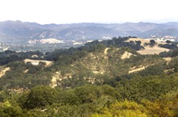
As it stands, the current proposal for Eagle Ranch includes incorporating its roughly 3,457 acres into the city, with up to 494 single-family residential lots, 93 multi-family units, a resort, a shopping center, and 15.2 acres of commercial highway space.
That property is owned by the Smiths, who in 1999 filed for a notice of nonrenewal on the property's Williamson Act contract, a renewable 10-year agreement to maintain the property as agricultural in exchange for tax breaks. The contract expired in 2009, making the land eligible for residential and commercial development.
The city's general plan identified Eagle Ranch as a future annexation area in 2002, and the SLO Local Agency Formation Commission (LAFCO) marked Eagle Ranch as within the city's sphere of influence in 2003, meaning that the physical boundaries of the ranch are within the Atascadero city government's influence.
In 2008, after years of conceptual designs, the City Council authorized city staff to process an application for the specific plan—addressing developmental standards, infrastructure requirements, implementation efforts and land uses, and a draft environmental impact report (EIR)—identifying the potential environmental effects of pursuing a proposed development.
Those documents were finally released for public comment earlier this year. It is the fifth version on the table, according to Vic Montgomery of RRM Design Group, the main applicant on the project.
"It's taken a long time. But we've actually prepared about five draft specific plans, and this is the final version of it," said Montgomery, who was authorized to speak on behalf of the developers.
The almost 10 years between authorization and the most recent draft of the development's plan consisted of meetings, City Council and Planning Commission hearings, and negotiating with neighbors who have homes bordering the ranch. Throughout the process, those living next to the ranch have provided feedback on what they'd like to see beyond their backyards.
"We've been doing this long enough to know that neighborhood controversy is part of the gig these days. You might as well go talk to your neighbors early on, see what they're thinking, talk about what you want to do, and get their feedback, because you're going to get it sooner or later when you go to public hearings. It's better to have talked to them and worked it out," Montgomery said.
However, the Atascadero Neighborhood Alliance doesn't quite feel like all of the questions it raised were answered. In the review the alliance submitted on the draft EIR, the group comments that the project description is "vague and inadequate," doesn't demonstrate fiscal neutrality, and lacks "biological resource impact analyses." The alliance points to these as some of the main reasons not to annex Eagle Ranch to Atascadero.
"The alliance requests that the city suspend any further consideration of the project until a draft EIR that fully discloses, analyzes, and attempts to mitigate the impacts of the project has been prepared and recirculated for public review and comment. The alliance objects to any further action by the city on the project until the necessary and proper environmental review has been completed," the alliance's comments state.
Urban sprawl, rural feel
With one hand on a large blueprint of Eagle Ranch, Montgomery traced his finger over the lime green areas color-coded as open space.
"As proposed, almost 74 percent of the ranch is preserved open space. To my knowledge, one of the highest percentages of open space for a project in the county," Montgomery said.
The ranch would consist of more than 2,000 acres of open space, 16.9 miles of hiking trails, and access to property that's been off-limits to the public since 1913. Additionally, an agricultural easement agreement with The Land Conservancy of SLO County permanently preserves 3,255 acres neighboring Eagle Ranch as ag land and open space—marking the largest conservation easement donated to the conservancy. This easement includes 36 parcels, Eagle Peak, Eagle Lake, and numerous Salinas River tributaries, such as Paloma Creek.
Regardless of those plans to maintain the area's rural character, community members have criticized the development's specific plan for not being detailed enough about how it will mitigate the potential environmental impacts. One of the criticisms is that the plan defers mentioning specific mitigation efforts to a later date. Additionally, some residents are concerned that the draft EIR uses old data in its environmental analysis of impacts such as air quality or biological resources, when more recent data is available.
Traffic is another major concern. Two major entrances are proposed for the ranch as well as a network of interior roads providing access from the ranch to highways 101 and 41. Two emergency access roads are also proposed within the area. To keep up with Cal Fire standards, those roads would have to be paved, at least 50-feet wide, and able to hold a 10-ton fire truck.
One of the emergency roads is slated to be built near Heesch's Lindal cedar house, but the existing right-of-way is quite steep. In the West San Diego road neighborhood where Heesch lives, there's currently only one way in and out of the ranch.
"The fire department doesn't like that. So the city said, 'As part of your project, you need to solve that problem for us, because we can't find a way to require right of way to create a second way in and out,'" Montgomery said.
Although it will be Eagle Ranch residents who would have to pay for the costs of road maintenance through a homeowners' association, neighbors like Heesch are still wary about thousands of new cars using their streets as shortcuts to the ranch and the state highways. He said the windy roads near his home are prone to accidents, and roads in Atascadero already need repairs.
Heesch's home is also in a high hazard landslide area. If developers build a road near his home, the steep ground beyond his yard would have to be filled in to create a level roadway. He believes that the topography and geology near his home would make it "damn near impossible" to build a road that's safe to use in emergencies.
"If this is such a valuable access to the ranch, why did the city and fire department allow this house to go ... for sale to a private ownership?" Heesch said about his home. "That puts you into the fire, that doesn't take you out."
Economics of growth
When the development is taken off hold, environmental consultants and city staff are required to address every comment in writing for the final EIR. The fiscal impact analysis will then be sent out for public review, and if developers can reach an agreement on moving forward, LAFCO will annex the property into city limits. The project is scheduled to be built in 10 phases over 20 years.
But, according to RRM's Montgomery, the Eagle Ranch developers are having trouble deciding what should be built first. A project that is solely residential can strain city services if it isn't being neutralized by property taxes. Developers say that the hotel and resort will be a lucrative source of profit for the city, but the city is requiring that the residential phases of the project be revenue neutral for Atascadero. Without the funds anticipated from commercial components of the project, developers are left "in a sticky spot," Montgomery said.
"The city's requirement is they want it to be revenue neutral without the commercial development. That is a high bar, because the city's police and fire services are so expensive. So we were looking at what impact that has on the homeowner's association, or the homeowners who are ultimately going to be paying for it," Montgomery said.
In an April 16 opinion piece published in the San Luis Obispo Tribune, Eagle Ranch owners Greg and Jeff Smith stated that the development will be revenue neutral for the city. But a fiscal plan wasn't started for the project until just before developmers placed the project on hold, according to Community Development Director Dunsmore.
"[The Fiscal Impact Analysis] hasn't been going on for very long. It's a separate document. The specific plan itself puts out a great design plan," Dunsmore said. "But a fiscal analysis, just on a bigger definition, what it comes down to is a best guess of what kind of revenue the project will bring in, and what kind of costs the project will entail on public services and taxation and all the like."
Upon annexation, the city would take on the responsibility for funding services to Eagle Ranch.
A joint City Council-Planning Commission meeting in 2012 referred to a fiscal plan being drafted to determine the project's financial impact on the city. The meeting's minutes state that the study's preliminary results found that residential "property taxes alone are insufficient to cover the added ongoing cost of city services to serve the additional population at Eagle Ranch."
City staff discussed renegotiating the property tax split between the city and the county (1/3 to the city, 2/3 to the county) in 2012, but it's unclear whether that will be pursued. Developers are currently looking at community finance districts, homeowners' associations, or a combination of the two to deal with the city's costs.
"That's all tangled up with ... how you make it work when you have all of this infrastructure that you need," Montgomery said. "It's sort of back to the economics drawing board." Δ
Reach New Times editorial intern Erica Hudson through the editor at [email protected].
Latest in News
Readers also liked…
-

Coast Unified teachers upset over new position's salary and qualifications
Oct 20, 2022 -
SLO police identify alleged driver who hit and killed couple
Dec 22, 2022 -
When the levee breaks: Oceano residents, county officials walk a tightrope of regulations to manage Arroyo Grande Creek, which some say led to the levee's failure in January
May 18, 2023

