
Steelhead wanted: Conservation groups collaborate to reinvigorate SLO County's fisheries and improve the quality of its watersheds
By Camillia Lanham[{
"name": "Ad - Medium Rectangle CC01 - 300x250",
"id": "AdMediumRectangleCC01300x250",
"class": "inlineCenter",
"insertPoint": "8",
"component": "2963441",
"requiredCountToDisplay": "12"
},{
"name": "Ad - Medium Rectangle LC01 - 300x250",
"id": "AdMediumRectangleCC01300x250",
"class": "inlineCenter",
"insertPoint": "18",
"component": "2963441",
"requiredCountToDisplay": "22"
},{
"name": "Ad - Medium Rectangle LC09 - 300x250",
"id": "AdMediumRectangleLC09300x250",
"class": "inlineCenter",
"insertPoint": "28",
"component": "3252660",
"requiredCountToDisplay": "32"
}]
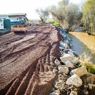
Muddy water is puddled in the bottom of what looks like a pond. It hides behind a berm next to neatly trimmed orange trees that mingle with avocado, lemon, and lime groves on a ranch up Santa Rosa Creek Road in Cambria. But it’s not a pond.
It doesn’t hold onto water like a pond or reservoir would. It’s just dirt and a little bit of vegetation: pretty unremarkable, really. But what it can do is absolutely remarkable.

This particular manmade curve in the earth captures runoff during storm events, allowing it to hang out for a little while, percolating down through sand, gravel, and small pebbles—feeding the shallow aquifer below it, slowing the flow of water that eventually makes it into Santa Rosa Creek and runs out to the ocean.
George Kendall calls it a sediment basin or a percolation basin.
“It’s a bit of like, restoration, I suppose,” he says from beneath the brim of his weathered cap. “Anything that farmers and ranchers can do to retain water higher in the basin is a good thing.”
Indirectly, measures like this one could also help provide a more secure supply of water for agriculture such as the rich, tart, and sour produce growing on his 90 acres. Kendall’s standing on the berm looking down into the hole, which can hold up to 1 acre-foot (almost 326,000 gallons) of water. He speculates that the groundwater level is probably about even with what’s visible at the bottom.
“It’s filled up four times this year and overflowed! And it’s doing its job, because [water] soaks in. And Santa Rosa Creek needs like 20 more of them,” Kendall, who once worked as a geologist, exclaims, almost jumping with jubilation. “To have an effect, you would need multiple landowners with these sediment basins on their property. The biggest reservoir we have is the ground, and you don’t have to build it; you just have to put water in it.”
Here’s the simple version of how it works: Instead of letting rain wash over the land, flush straight into the creeks, and rush out to the ocean at cubic-feet per second, Kendall is able to slow down up to 1 acre-foot per storm. It stays in the basin, soaks into the ground below it, and ekes toward the creek at cubic-feet per day.
Theoretically, storing that extra water below the surface means groundwater levels won’t sink as fast and the creek will have flow later into the dry season. The mantra goes something like “slow it, spread it, sink it, share it.”
According to Devin Best, the executive director of the Upper Salinas-Las Tablas Resource Conservation District (RCD), projects like Kendall’s also help improve water quality and potential steelhead habitat, reduce erosion and sediment runoff, and prevent flooding downstream. It benefits all those fighting interests that can often fog up the clarity of watershed management—municipal and residential needs, irrigation needs, habitat restoration, land use, endangered species, water rights, groundwater recharge, flood prevention, etc.
“A lot of people say, ‘Oh, farmers don’t care,’ and farmers do care, a lot,” said Best, who helped Kendall get permits from five different agencies to build the basin. “I can talk with the regulator and know their concerns and talk with the farmer and know their concerns and work with both to try and bridge the gap.”
That’s basically how the majority of conservation happens in SLO County—a collaboration between parties to manage a resource that trickles from public forested land to private ranches, farms, and residences and into cities before heading for the Pacific. Through the fledgling Central Coast Water Conservancy, SLO County conservationists are pooling their collective relationships and minds with the goal of reviving lost steelhead habitat (a native fish that’s listed as an endangered and thought of as an indicator species for the health of a watershed) and benefitting all those other things that are wrapped up in watershed management.
It’s sort of a one-step, one-fish at a time approach, and all of it looks at how the water flowing through our county—above or below ground—can get a little boost.
Surface flow
The Water Conservancy brings all the stakeholders to the table who would normally be competing for grant funding, and basically helps prioritize the projects applying for money.
For instance, Central Coast Salmon Enhancement—a nonprofit based in Arroyo Grande that works to understand and restore watersheds and their fisheries from Big Sur to Ventura—recently received an almost $200,000 Proposition 1 funded grant through the California Department of Fish and Wildlife to monitor 60 creek sites throughout the SLO County.
“And the main thing we’re looking at is: Does it dry up? Does it flow?” said Aleksandra Wydzga, a hydrogeologist with Salmon Enhancement who also teaches at Cal Poly. “We’re missing some critical data, and we’re trying to get that data so we can more effectively plan on a county level.”

They need to figure out what water currents are like in SLO County creeks and tributaries throughout the year and determine how much water is needed to sustain the fish throughout their life stages: eggs, fry, juveniles, adults, and those in migration. Steelhead operate like salmon in that they move between fresh water and the ocean, migrating from the Pacific through an estuary into a watershed to lay their eggs. The data will help the Water Conservancy determine where the best potential habitat is and where effort and money is best spent.
The project will continue the monitoring work already started on Pismo Creek—considered to be prime steelhead habitat—by Stillwater Sciences and Salmon Enhancement.
Ethan Bell, an aquatic ecologist with Stillwater, pulls rubber waders over his shorts in a big parking lot by the Price House in Pismo on a bright Tuesday in March.
Green hills rise up to yellow mustard behind him. He faces the sound of multi-million dollar homes under construction halfway up the hill in front of him. Rain that can’t soak into the earth through pavement and packed dirt streams into Pismo Creek, picking up sediment, pollutants, and debris as gravity pushes it down to the lowest point.
Bell finds a path down to one of Stillwater’s testing sites. Shadows cool the air along the creek, which meanders at 1 cubic-foot-per-second, according to the long gray instrument Bell is holding to measure the water flow and depth by his submerged feet.
“It’s kind of a trip that there’s all of this water down here,” Bell says. “And if you go up to the top of Pismo Creek, it’s dry.”
A few miles upstream, right as Pismo Creek splits into West Corral de Piedra and East Corral de Piedra creeks in the Edna Valley, that flow disappears into the earth before reappearing on the eastern side in the hills below Righetti Dam (which happens to be one of the largest private dams in California).
Water is moving underneath the surface until it reaches Price Canyon, where it’s popped up into Pismo Creek by a bedrock fault. For the last four years of drought, there hasn’t been enough water in Edna Valley to make itself visible in the Corral de Piedra creeks. Stillwater had to extend the study an extra year because there was a lack of water to monitor above Pismo Creek.
“In many reaches, there’s not enough at current levels to sustain fish. … There are times when flows are enough below Righetti Dam,” Bell says. “But there are times when the flow goes completely dry.”
Mind you, Righetti Dam isn’t the only water-diverting obstacle in that reach. There are wineries, residences, ranches, and farms. There are beaver dams, roads, railways, and bridges. There are decades’ worth of sediment built up and barriers created inadvertently because of development. Each thing adds a little bit of blockage, changing the way water flows over time and making it harder for fish to find their way into the creek from the ocean and fight the current to swim upstream.
“In this watershed, it’s not like there’s some huge water company with their hand on the dial,” Bell says. “In this case, it would take a large collaboration between multiple diverters [to help supplement water levels].”
Steelhead can survive
Standing next to San Luis Obispo Creek days after a March rain, it’s hard to believe that farther downstream, it will stop flowing this summer. Rippling water stretches 10 feet or more between the banks off Fox Hollow Road, looking northeast into Reservoir Canyon.

But this part of the creek’s watershed is what’s known as a losing reach. As the weather gets hot and dry, so does the creek bed. The water filters back into the ground as it flows downstream, similar to what happens in the Edna Valley below Righetti Dam.
Freddy Otte, SLO’s city biologist, shifts his gaze from the water to corrugated metal that he can’t wait to take advantage of.
“It pains me every time I drive by this facility and it’s raining, because this facility is really a no-brainer, it’s just not ready yet,” Otte says. The rusty curves cover an old reservoir that SLO hasn’t used in decades. He means to take that old roof and repurpose it as a cistern to supplement creek flows as they start to dry up, capturing up to 500,000 gallons of rainwater to store in the cement reservoir it’s covering.
“For about $100,000, we could have the system up and running and start augmenting the flow,” Otte says. “This is a beneficial reuse of a precious resource and in a state with an endangered species.”
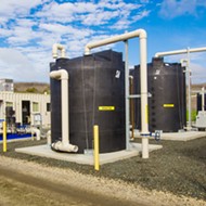
It would mimic part of a similar project completed in the hills behind the SLO County Office of Education in 2012 at the Cal Poly Beef Unit, where roofs were repurposed into cisterns to supplement water for cattle in the summertime.
Rain gushes off shiny green metal roofs into filters before being gravity fed downhill into gigantic tanks that can hold more than 400,000 gallons of water. In an ideal rain year, which Cal Poly Agricultural Operations Director Kevin Piper said hasn’t happened since the system was installed, the captured rainwater would be used to quench cattle thirst rather than pulling from riparian wells along Pennington Creek. The theory is that Pennington Creek—which flows into Chorro Creek and into the Morro Bay Estuary—will keep water longer into the dry season.
According to Meredith Hardy, a California Conservation Corps fish habitat specialist who helped design and install the system, one project like this doesn’t make a huge difference. It’s cumulative.
In mid-April, as she drives down the road leading back to the SLO County Office of Education, she points out a severely sloped roof at the Rancho El Chorro Outdoor School and says they will eventually be turning that into a cistern.
“I can’t look at a roof the same anymore,” she says, shaking her head with a laugh.
Below the corrugated metal on Fox Hollow Road, an old pipe runs from the reservoir down to Cuesta Park, where it pops out of the ground and could potentially be used to enhance SLO Creek’s water flow during the dry season. Otte has big plans, and Wyzdga with Salmon Enhancement is solidly on board with them.
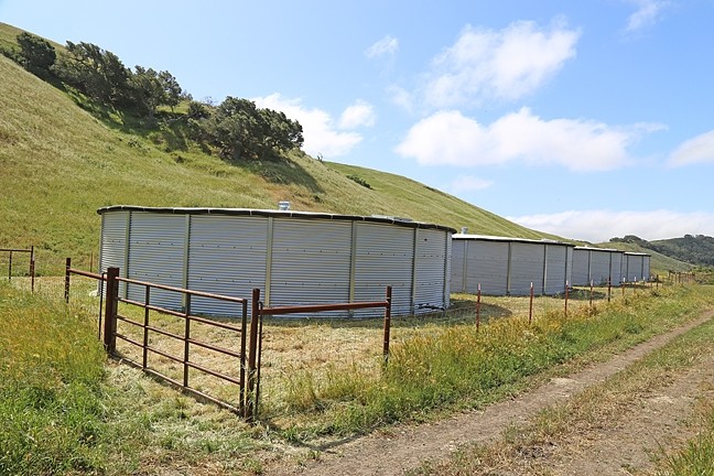
Otte’s plan has three phases that add up to eventually capturing up to 7 million gallons of water to supplement SLO Creek.
Although the creek naturally goes dry just before it runs through Cuesta Park, the creek bed was manipulated to allow for fish passage over a cement barrier, and it created these large pools of water below it.
Conservation work enhanced the changes by installing veins of rock across the creek. Now a series of deep pools casually bubbles through Cuesta Park. The gentle gurgle of movement through coarse gravel beneath the shade of overhanging vegetation has the right combination of everything steelhead need, as long as it’s got flow.
“It created ideal conditions that we’re trying to maintain,” Wyzdga says. “And so you have to look at the historical, but you also have to look at the modern. You have to be somewhat opportunistic.”
Steelhead do take what they can get—Wyzdga says they’ve counted redds (egg nests) in that stretch of water.
Changing ways
Those casual pools in Cuesta Park are doing exactly the same thing that Kendall’s sediment basin is doing in Cambria. Slowing the movement of water down. Spreading it out on the earth. Enabling it to stay higher in the watershed, maintain stream flows, and soak into the ground.
This is a huge shift in thinking about how to deal with water, according to Steph Wald, the watershed projects manager with Central Coast Salmon Enhancement. Although conservationists have advocated for these methods for many years, it’s catching on elsewhere—in 2014, California voters passed Proposition 1, allocating $510 million for water management projects, including those that enhance watersheds and steelhead habitat.
“It’s been slow to evolve and develop,” she said. “We’re getting back to reversing probably the last 70 years of engineering thinking. We’ve been losing this resource for years because we’ve basically tried to get it off the land as quickly as possible.”

Old manmade drainage ditches and cement storm water outfalls in cities like Paso Robles push runoff into creeks like Centennial, which drains into the Salinas River. That mad rush careens into the creekbeds, cutting deep channels into the earth, causing the water to charge even faster, eroding the banks, and destroying riparian habitat as it sprints into the riverbed with all the trash, pollutants, and sediment it can handle.
Best with the Upper Salinas-Las Tablas Resource Conservation District is working to remedy some of that one section of creekbed at a time. In April, he met up with Hardy from the Conservation Corps to discuss which section to tackle next.
They admire their handiwork from last year. What was once a deep canyon with nothing to hold water back is now planted with vegetation and calmed with rocks to create a sort of basin for the water to pool up in. But after 100 feet, the pitted cavern comes back to life, and they take turns walking it—talking about where they can put a meander back into the creek to slow the way water moves down it.
“If we don’t do it, it’s just going to get worse,” Best says. “And at some point, it’s going to get so bad that the species is going to get extirpated—and go extinct on the Salinas River.”
It’s not that steelhead would necessarily use Centennial as a hatching ground, but everything feeds everything else in the end.
He draws a hydrograph to make his point, saying the flows are much flashier than they used to be. One bell curve stretches longer than the other one, and one stretches higher. The difference between the two is how water flow has changed over the last 100 to 150 years. The higher one demonstrates that more water courses through our rivers and creeks in a shorter period of time than it used to, drying up those channels earlier in the year.
The goal is to capture the difference between those two graphs, and use it to benefit everything in the watershed.
In an old wooden barn on Santa Rosa Creek Road, Kendall pulls out a well-worn map of the properties next to his. He uses a finger to trace the creek’s tributaries. They’re all similar, like his, straightened out on the low side of the parcels. He thinks that started happening in the mid to late 1800s.
“So when we get a big rainstorm, it shoots down the channel instead of spreading out in the flat areas like it used to,” he says. “It happened a long time ago, and now we’re thinking about the consequences. So how do you mitigate that?”
All Editor Camillia Lanham does is think about consequences. Send comments or angry letters to [email protected].

Latest in News
-

Access to education: FAFSA's new application process was supposed to make it easier for students to apply for help with college tuition, but it did the opposite for some
Apr 18, 2024 -

San Luis Coastal will begin offering ethnic studies classes next fall
Apr 18, 2024 -
A dispute over a Cambria CSD well on school district property leads to eminent domain threat
Apr 18, 2024 - More »
Readers also liked…
-
Coast Unified teachers upset over new position's salary and qualifications
Oct 20, 2022 -
SLO police identify alleged driver who hit and killed couple
Dec 22, 2022 -
When the levee breaks: Oceano residents, county officials walk a tightrope of regulations to manage Arroyo Grande Creek, which some say led to the levee's failure in January
May 18, 2023

More by Camillia Lanham


